Map by Steve Hyde
Research by Dr. Jim MacRae
by Dominic Corva
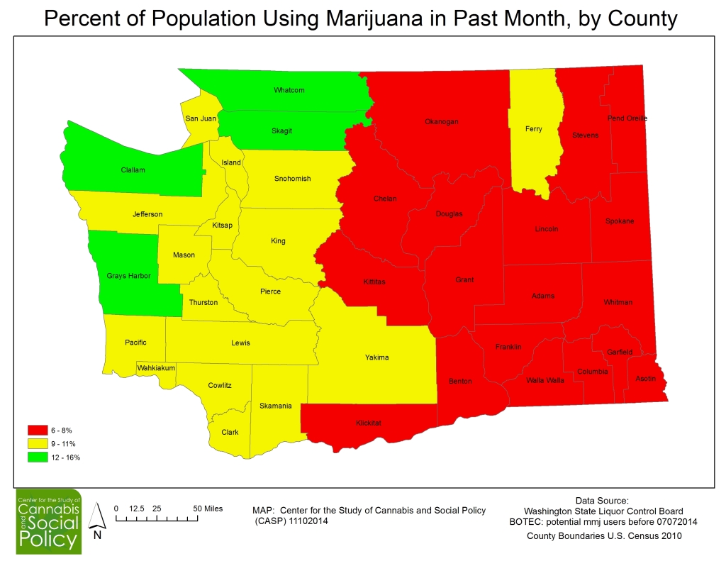
This map, created from data produced by BOTEC for the Washington State Liquor Control Board, shows how the WSLCB understood the cultural geography of cannabis consumption by county level in Washington State as they embarked upon their rule-making process. This information was used to calculate canopy limits and allocate retail stores to jurisdictions a year ago.
The purpose of creating this map is two fold: first, to help the public and policymakers understand how cultural geography shapes bureaucratic rulemaking; and second, to help the public and policy makers understand better how cannabis market consumption (not just legal consumption) is unevenly distributed throughout the state.
This “one-map story” is the first in an ongoing series aimed at helping people understand the geography of cannabis policy landscapes, one digestible bit at a time. More complex analyses depend upon understanding how all the stories fit together, but the following paragraphs provide starting points for such analyses.
First, there is a clear East/West relationship may map, to some extent, onto existing state political geographies: conservative/liberal; rural/urban; and to the I-5 corridor which extends south of the border but also north of the border. We could look further at the first two by finding existing county-level maps, but the third requires a little more thought.
While I-90 is a major East-West corridor, it does not lead through major urban consumption areas. The North-South corridor leads to and through Vancouver, Seattle, Tacoma, Portland, and Eugene; from Eugene to the south is the cannabis agricultural breadbaskets of Southern Oregon and Northern California. It’s also the major historical corridor for hippie migration from the Bay Area at the end of the 1960s.
We can also say with weak confidence (given data limitations and methodological challenges) that there appear to be five anomalous counties: Three of them (Whatcom, Skagit, and Clallam) are in the Northwest of the state, where lots of intentional communities sprang up in the 1970s. We also note that southwest British Colombia may have stronger cultural geographies of consumption that Washington state. Grey’s Harbor is on the Peninsula not far from where Ed Rosenthal outed the first commercial indoor grow he’d ever seen in a 1987 Whole Earth Catalog article; and Ferry county in the northeast may share some combination of the Northwest cannabis consumption geographies as well as being a historical corridor for BC cannabis entering the U.S. (this all-but ended after 2001).
One map stories root our geographical investigations by showing us spatial relationships that must be further explained. Look forward to more on a regular basis!
